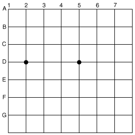
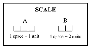
A map is used to identify locations. This is done by plotting points, called coordinates, on a labeled grid. A grid on a map is a series of horizontal and vertical lines forming squares on it. Maps can be used to compute the distance between two locations, or between two coordinates. There is an equal distance between each horizontal line on the grid, and each space between two lines represents one unit of measurement. This is the same for the vertical lines as well. There is a scale on maps that indicates the value of each unit of measurement. For example, each space between the horizontal and vertical lines could represent one foot or one mile. Additionally, since maps usually cover a very large area, often times the legend indicates that one space equals two units of measurement or more. In the example below, each space equals 1 unit in A, but in B, each space equals 2 units. A map is used to identify locations. This is done by plotting points, called coordinates, on a labeled grid. A grid on a map is a series of horizontal and vertical lines forming squares on it. Maps can be used to compute the distance between two locations, or between two coordinates. There is an equal distance between each horizontal line on the grid, and each space between two lines represents one unit of measurement. This is the same for the vertical lines as well. There is a scale on maps that indicates the value of each unit of measurement. For example, each space between the horizontal and vertical lines could represent one foot or one mile. Additionally, since maps usually cover a very large area, often times the legend indicates that one space equals two units of measurement or more. In the example below, each space equals 1 unit in A, but in B, each space equals 2 units.
|