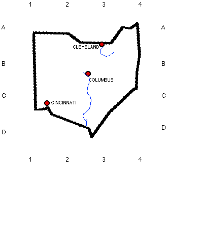
1. Look at the map of Ohio, On the side of the map there are letters and on the top there are numbers. Cincinnati’s grid numbers are C1. Draw an imaginary line about where B3 meet. Name the city________________. CHECK YOUR ANSWER
1. Look at the map of Ohio,
On the side of the map there
are letters and on the top there are numbers. Cincinnati’s grid
numbers are C1. Draw an imaginary line about where B3 meet.
Name the city________________.
CHECK YOUR ANSWER
2. Now, look at grid location A4, this forms the most northern
point in Ohio. Look at the United
States map. You need to scroll down to see it . Which state is on
the eastern border of
Ohio?
a.
Kentucky
b. Illinois
c.
West Virginia
d.
Pennsylvania
3.The Ohio River forms
the southern border
of Ohio. Which two states are
on Ohio’s
southern border?
a.
Indiana and Illinois
b. Indiana and Kentucky
c. Kentucky and West Virginia
d. West Virginia and
Pennsylvania
4. What is the name of the state that is partially on
the northern border of
Ohio?
a.
Wisconsin
b.
Michigan
c. Indiana
d. KentuckyC
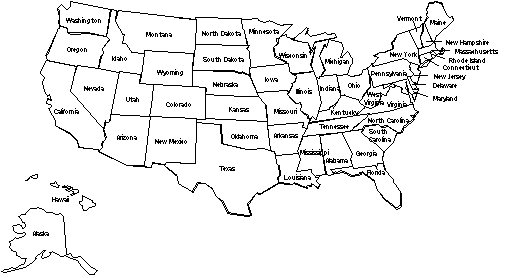
BONUS QUESTION: Name all the states that border
Lake Erie.
The states that border Lake
Erie are ________________________________ CHECK
YOUR ANSWER
![]() BACK
TO THE BEGINNING
BACK
TO THE BEGINNING