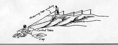
Fortunately, there is a small stream with sloping banks near the school. Students determined the ridgeline of the watershed and used stakes to mark its upper boundary. The stakes formed triangles with a control stake at the "bottom" of the watershed. Measurements were taken that resulted in a map of the watershed. Area of the watershed can be calculated using simple geometry. Using annual rain fall, volume of water going into the river can be estimated.
Source: Teacher's RiverGuide: A Curriculum Handbook on the Cuyahoga River. Keller, Simonis and Bolton, developed by WKSU, a service of Kent State University. Copies can be obtained from Cuyahoga Soil and Water Conservation District.

Go Back to Math-Science Connection
Go Back to Main Menu