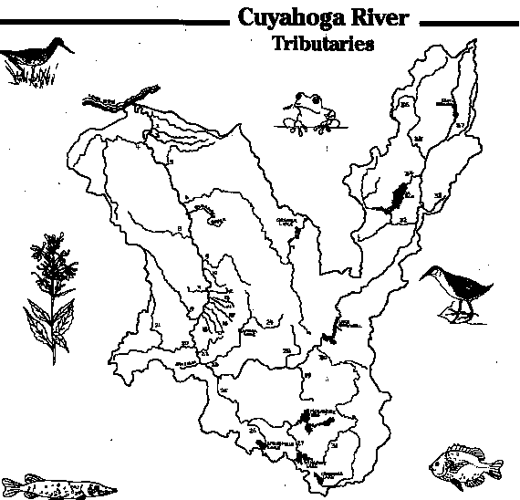
The Cuyahoga River Watershed drains 813 square miles of land in Geauga, Portage, Summit, and Cuyahoga Counties. This is less than 3% of the land in Ohio, but it houses over 16% of the state's population. This drainage system is called a watershed or a river basin. To be exact, a watershed is the total land area drained by a river and its tributaries.
This U-shaped watershed is divided into an Upper Section, Middle Section, and a Lower Section It includes more than thirty-seven plus named tributaries. The Cuyahoga River Watershed collects all the surface water that enters the basin as precipitation and sends it south, west, and north over a 100-mile course which ends at Lake Erie.
The Cuyahoga River Watershed begins in Geauga County with the West Branch and the East Branch in the Upper Section. The West Branch is considered a tributary and it consists of a wilderness of marshes and swamp forests. In fact, 25 miles of this Upper Section in Geauga and Portage Counties are designated as a state scenic river by the Ohio Department of Natural Resources.
A natural feature in this Upper Section is a rich abundance of spongy wetlands. This is beneficial because these wetlands filter sediment and other impurities, acting like natural dikes against fluctuating water levels. These wetlands also provide the richest habitats, including beaver lodges, goose nests, and mink latrines, on the planes where there is a diversity of wildlife. 1,361 acres of these wetlands in the Watershed are preserved by the Ohio Department of Natural Resources. Many of these are bogs and fens which were created when glacial ice melted in shallow clay depressions. Also included in the Upper Section, which is a rural area, includes many large marshes and shallow lakes.
The River continues in a southwest direction through Portage County passing the "falls" region of Kent,Cuyahoga Falls, and Akron where it becomes more populated.
The middle portion of the watershed in Summit County consists of the Cuyahoga Valley National Recreation Area, the largest park in the watershed. It occupies about 22 miles of the River from Akron to Cleveland.
Natural erosion in the middle valley of the Cuyahoga River Watershed causes streams to carry a heavy sediment load, which harms the aquatic environment. The run off from construction sites and insufficiently vegetated stream banks multiplies the sediment content of all our streams. The sediment washes into the navigation channel which has to be dredged out annually in order for the aquatic environment to be safe.
The lower region of the Cuyahoga River Watershed in Cuyahoga County is dominated by industry and dense urban development. The most intensive industrial development is located between Big Creek and Lake Erie. Industry occupies 12% of the land area in the lower region, and two-thirds of the watershed's population resides here. The problem is that these industrial and urban ares are developed right up to the banks of the River. The highways, roads, culverts, and sewers are part of the Cuyahoga drainage, the sewer system being the dominant drainage. Since sewers and paved surfaces lack the rich habitat and cleansing abilities of natural streams, they simply flush water directly into the stream at the end of their course allowing dissolved and solid material including toxins to enter the River system.
Over thirty-seven named tributaries, not including the unnamed streams and rivulets, that makeup the natural network of the River System and travel 286 miles into the Cuyahoga. Of these, Tinkers Creek, being 28.2 miles long and draining an area 96.4 miles, is the longest tributary in the Watershed. Another tributary is Slipper Run. Falling an average of 188.3 feet per mile, it has the steepest elevation and is the shortest direct tributary at 2.3 miles in length. The only tributary that runs past a rainforest is Big Creek, the most-heavily used of the gems in Cleveland Metro Park's emerald necklace. Some other tributaries are the Little Cuyahoga River, an urban river, and Breakneck Creek which is judged to have some of the best drinking water in the country.
Some of the tributaries are breathtakingly beautiful. These include the spongy wetlands in the West Branch, the wildflower-rich plain of Furnace Run, the majestic 65 foot falls of Brandywine Creek, the magnificent hemlock-linked gorges of Tinker's Creek, the wildly diverse terrain of Big Creek, and the unique urban meanders of Mill Creek. Parks and recreation areas occupy many of these remarkable tributaries.
Although the Cuyahoga River Watershed has beautiful tributaries, it also has areas that are a disgrace. They are strangled, polluted, and diverted almost out of existence. In fact, only two out of the ten tributaries monitored by the Ohio EPA in a 1991 survey fully met the standards for fish communities. This means that we need to work together a little harder at giving our River care and attention to keep it a little cleaner.
Return to Overview